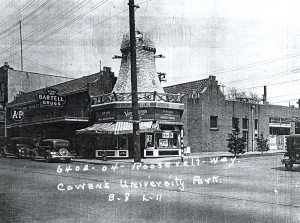
Northeast corner of Roosevelt Way NE and NE 64th Street, ca. 1938. Courtesy Puget Sound Regional Archives.
Of all Seattle’s rich historical resources, my favorite might be the King County Land Use Survey photograph collection. These images document every structure standing in King County in the late 1930s, and many built subsequently.
King County Land Use Survey photographer captures a house’s image, ca. 1938. Courtesy King County Archives.
Real estate agents like this collection, and if you’ve toured an open house in the Seattle area you may have seen the Land Use Survey photograph that captured that structure some rainy morning in 1938 or so. Land Use Survey staff also interviewed residents and made measurements. These records are a visual snapshot of our city in the waning years of the Great Depression.
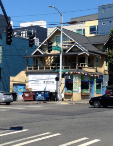
6501 Roosevelt Way NE, Seattle, July 2, 2015.
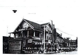
6501 Roosevelt Way NE, Seattle, ca. 1938. Courtesy Puget Sound Regional Archives.
I used this collection for a project that examined the homes that once filled what is now the Seattle Freeway/Interstate 5 corridor right-of-way. Freeway construction skirted what would decades later become my own neighborhood, and I wanted to be able to envision the streets and homes and churches and businesses right-of-way clearing had obliterated. The Land Use Survey photos stitched these Lost Neighborhoods back into my mental image of my built environment.
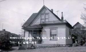
710 E (NE) 56th Street, Seattle, now part of I-5 right-of-way. Courtesy Puget Sound Regional Archives.
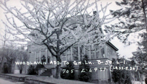
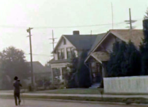
705 E (NE) 69th Street, Seattle, is now part of the I-5 right-of-way. Courtesy Puget Sound Regional Archives.
The Land Use Survey collection has also served me as a finding aid to Seattle author Betty MacDonald’s houses, the trail of breadcrumbs I first followed toward the adventure that is evolving into Looking For Betty MacDonald: The Egg, The Plague, Mrs. Piggle-Wiggle and I.
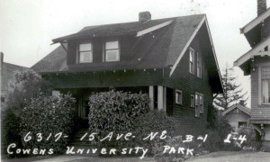
6317 15th Avenue NE, Seattle, home to Betty MacDonald and her family during the 1930s. Courtesy Puget Sound Regional Archives.
The Land Use Survey photos are housed at the Puget Sound branch of the Washington State Archives on the Bellevue College campus. Call with a parcel number for any property in King County, and most likely you will be able to arrange a visit to see the image and other property information. Explore your favorite neighborhood circa 1939 by asking to see several blocks worth of parcel number photographs. I “walked” down Roosevelt Way NE that way a few years ago. It was amazing.
6500 Roosevelt Way NE, Seattle, July 2, 2015.
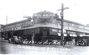
6500 Roosevelt Way NE, Seattle, ca. 1938. Courtesy Puget Sound Regional Archives.
July 3, 2015
